
Sheltowee Trace Trail
Are you ready to take a truly epic hike? Gear up for more than 300 miles of breathtaking backcountry adventure on the connected hiking and mountain biking trails offering so many things to see and do along the Sheltowee Trace National Recreation Trail.
As Kentucky’s longest trail system, it stretches north from the Tennessee border through the mountainous Big South Fork National River & Recreational Area and spans densely wooded Daniel Boone National Forest in the south-central part of the state. From there, it winds into Eastern Kentucky and the vast Red River Gorge, providing multiple access points, trail lengths and difficulty levels for a wide range of day hikes and outdoor experiences.
Hiking Trails
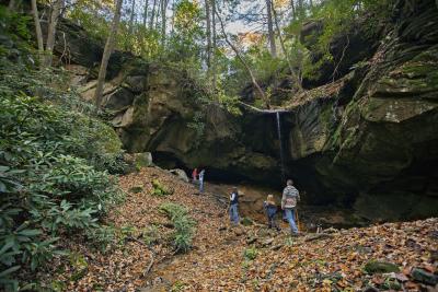
Although hiking throughout most of the Sheltowee Trace Trail would be considered moderate, there are treks that take on steep climbs and drops over untamed rugged terrain, along narrow ridges, through deep gorges and below towering cliffs. The “work” is totally worth it, though – you’ll be rewarded with equally jaw-dropping views.
If you’re looking for a lighter workout, just follow scenic marked pathways on what the USDA National Forest Service calls the “trail system backbone of the Daniel Boone National Forest” to take advantage of local looping trails for shorter, leisurely nature strolls, rides or connecting thru-hikes.
Water Recreation
And fun on the water? You bet!
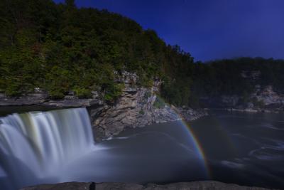
You’ll discover incredible natural wonders all along the Sheltowee Trace Trail, including crossable natural sandstone bridges and stunning waterfalls like massive Cumberland Falls, a dramatic 125-foot wall of water dropping 60 feet that is known as the “Niagara of the South.” It’s also the only place in the Western Hemisphere where you can see a one-of-a-kind lunar “moonbow,” a natural phenomenon created in the mist of the falls under a full moon.
London’s Laurel River Lake lies in the heart of Daniel Boone National Forest, offering more than 200 miles of tree-lined shores and some 5,600 acres of clear water perfect for boating, water skiing, scuba diving, fishing and swimming. Trails around the park provide plenty of places for hiking, horseback riding, wildlife viewing and scenic picnics, too. Further north near Morehead, Cave Run Lake is a peaceful setting for lazy days of boating, floating, tubing and more, along with beautiful camping spots where you can sleep under the stars.
Continuing along “The Trace,” you’ll find beautifully rugged scenery and spectacular vistas at every turn, with views changing with the seasons. Waterfalls and wildflowers are at their peak in spring, while cool nights and brilliant fall foliage color your hikes in the fall.
History & Culture
You’ll also learn the history of Daniel Boone’s trek through the wilderness here and his relationship with Native American leader Chief Blackfish, war chief of the Shawnee Indians. (Did you know the trail was actually named in honor of Boone? Sheltowee, meaning “Big Turtle,” was the name Boone was given by the Shawnee tribe.)
And when you’re ready for a few city amenities, you can stop off at a connecting certified Kentucky Trail Town for local dining, shopping, supplies and lodging in a historic downtown – including picturesque Morehead, where the Sheltowee Trace runs right down Main Street, or historic Stearns, where you can enjoy a delicious dinner at the Whistle Stop Café.
If you are interested in an interactive map, scenic index, or a site map, call (859) 806-3938 or visit www.sheltoweetrace.com.


Hidden Gems in the Kentucky Wildlands

Liberty Park Veteran's Wall
The Veteran’s Wall is a memorial dedicated to all U.S. Service Members from Liberty...

Asher Hunting Access Area
This area is open to hunting for statewide regulations and rules and regulations in...

Zilpo Road National Forest Scenic Byway
The Zilpo Scenic Byway is a gently curving eleven mile road with a travel time of...

